

Envision yourself on the river, the James River. Envision yourself on a rock in the middle of the river with water flowing by. Now turn 360 degrees in place and take in the vistas that surround you.
Starting this summer, two Richmond-based entrepreneurs are teaming up to make their vision of the James a reality, a reality possible from any device with access to the Internet.
At the heart of Virginia, the James River carves a 348-mile-long path full of history, beauty, and recreation across the state. Andy Thompson and Ryan Abrahamsen want to allow you to travel the length of this watershed and witness the mountains and landmarks it passes—all in a single sitting.
Thompson and Abrahamsen are no newcomers to incubating ideas and turning them into reality. Thompson has been a contributor to the success of the Richmond outdoor scene for years. In the past, he wrote the outdoor column for Richmond Times-Dispatch. However, these days, he is both founder and operator of RichmondOutside.com, an online resource that covers anything and everything involving outdoor news and recreation across the Richmond region.
Abrahamsen is co-owner of Terrain360.com, an interactive website that takes viewers on a visual tour of some of the most beautiful places in and around Virginia through a 360-degree panoramic view of the terrain surrounding selected trails. Between Abrahamsen and Thompson, you can find just about any content you need to saddle up for your next adventure in the Commonwealth of Virginia.
Over the past three months, the duo has been perfecting their unique project along with the help of the James River Association. And soon Thompson and Abrahamsen will float and map the entire James River watershed in a way that has never been done before.
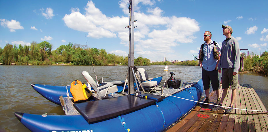
To successfully navigate the entire length of the river, the team has fabricated an inflatable 8-by-16 pontoon raft with an aluminum-framed deck. Rising straight up and out of the middle of the vessel is a stainless steel, telescoping camera rig. Atop the mount is an array of six cameras facing in all directions, which produce 360-degree panoramic images.
They call it Photohontas, and it’s like nothing you have seen before.
By constructing this one-of-a-kind camera raft, Thompson and Abrahamsen will be able to descend all 300-plus miles of the James River, as well as some of its major tributaries, while snapping 360-degree panoramic images about every 30 feet along the way. At the end of the trip, they will stitch all the pictures together forming about 60,000 panoramic images.
Using the technology of Terrain360.com, these panoramas will be compiled together to form one 3D map. “Our goal is to offer a unique experience for river lovers,” says Thompson. Anyone, anywhere, with Internet access, can take a virtual tour down the James River, creating an experience like none other. In addition, there will be informational icons built into the project to allow the viewer to click and learn about the many landmarks found on our nation’s founding river.
Thompson says that Richmonders should be on the lookout for the Photohontas later this summer as it drops the falls of the James with the city skyline in the background. And if you see the Photohontas floating the James, it will see you, which means you may just find yourself captured on film and part of the legacy that is the James River.
Stay tuned to RichmondOutside.com, EnvisiontheJames.org, and Terrain360.com to check out the finished product.